
Here you will find the stories behind some of my photos. My photography attempts to capture images that are influenced by Archeological Anthropology. They are images of places and things which time has left behind, and the images focus on the “ruins” of America. They are places that interstates and expressways avoid and that I find while driving endless miles in order to find that one perfect photograph
Mesa Verde (Part 5 of 8)
The fifty mile drive from Durango to Mesa Verde brought to mind all the college lectures and lessons that I learned while majoring in Anthropology. Mesa Verde and the Anasazi was a prominent topic in more than a few classes that I took. Mesa Verde is the only national park devoted to the preservation of archeological
 sites and is a site where the Anasazi lived 700 years ago. It includes over 4,500 man-made archeological sites. Mesa Verde is so unique that not only is it a national park but it is also a UNESCO World Heritage site.
Sometime between graduating with the degree and now, a decision was made that these proud people should not be called Anasazi. Anasazi has a few meanings. The first meaning is “ancient people” and the second “enemy ancestors.” It may also mean “the ancient foreigners.” Since the modern Ute, Hopi and Navaho nations claim to be decedents of these people, the Anasazi are now called Ancestral Puebloan.
As I entered the park, the imposing Mesa Verde Point stared down at me. It is the highest point within the park. As I continued down the road, acres of bare, burned pine and juniper trees dotted the landscape. There are several areas of the park that had experienced irreparable fire damage. However, the remains of these trees give a haunting image of hands with outstretched fingers reaching out to the heavens. As I continued my drive through the park, I saw amazing views of the landscape. Mesa is spanish for table, and while driving throughout the park, I saw many of these flat tops and the ravines between them. Below these flat tops are where the cliff dwellings are found.
While driving though the park on the way to the visitor center, my anthropology classes came to mind again as well as my fear of heights. I recalled from one of my classes that the cliff dwellings involved vertical climbing. I didn’t exactly recall the height of the dwelling, but I remembered that they were steep. I struggled with the idea of leaving Mesa Verde without walking though one of the houses. After arriving at the visitor center and evaluating my options, I decided to visit Cliff Palace. Cliff Palace has a 100 foot vertical climb and five 8 to 10 foot ladders. The other two sites, Balcony House and Long House were beyond my comfort zone. Long House has a 130 foot elevation and Balcony House has a 60 foot open face climb.
To avoid damage to the dwellings, sightseeing is supervised by Park Rangers and limited to a number of people per hour so tickets are required to visit the dwelling. I attended the 11:30 tour with a park ranger called Zac. He pointed out that he joined the service two weeks earlier and that this was his fifth tour group. It was his second for the day and that the other three were done the day before. Even though he was not a seasoned ranger, he was very knowledgeable. He pointed out that the term Anasazi is no longer favored and that the park is the only national park devoted to preserving man-made and not solely natural resources.
My time down in Cliff Palace was astounding. To see how people lived so long ago and to see how they can build a dwelling out of stone with 150 rooms was amazing. The park ranger explained that in order for that to be accomplished, the one hundred people that lived there must have worked in unison, sort of like a barn raising. The stones would have had to have been carried from other locations to the alcoves in the cliff. He explained that some of the people would have had a lot of motivation to complete a wall by showing examples of the intricate brick work of some of the rooms. In other places, the brick was laid haphazardly. My own experience working on my own house came to mind. I would describe the renovation work I did with each room’s sheet rock as excellent for an amateur. Renovating my own house was the best motivation. When I sell the house, I’m sure the future owners will describe it as haphazard as they laugh at the workmanship.
Cliff Palace may be a archeological ruin, but it is also a piece of artwork and a photographic treasure. My camera worked overtime. I photographed the site from every imaginable angle, under the watchful eye of the ranger. The rooms could not be entered. The walls could not be touched and my time was limited. All of this was to rightly protect these resources for generations to come. I’m glad that I could put aside my issues with heights, to walk in the shadows of the Puebloans.
After leaving Cliff Palace, my next stop was the self guided tour of Spruce Tree House, another cliff dwelling. This one did not need a ticket and did not involve any ladders or time limit, but the rooms were also off limits. Nevertheless, this too was a piece of artwork and a photographic treasure. I spent at least a half hour photographing the shapes of the ruins. My camera was smoking at this point.
My last stop in Mesa Verde was the Ancestral Puebloans’ ancient farming community of Far View. Here too were some photographic gems. It was not a cliff dwelling but consisted of homes built on the mesa top. It is the ruins of a village with three houses and was a great photographic opportunity, with its contrasting brickwork.
I ended my visit at Mesa Verde and spent the night in Cortez, Co. My goal for the following day was to continue with the second half of the San Juan Skyway, taking me north on my journey back to Denver.
Colorado Springs to San Juan Skyway (Part 4 of 8)
The prior day, on the way up Pikes Peak in the back of the van, I had shared my plan to make it to Mesa Verde by nightfall had I not been stranded on the mountain. Since the two are nearly 400 miles apart, the locksmith corrected my guesswork and said it would take about six hours to drive to the National Park. This morning, my plan was to still drive some of the Colorado Springs Loop on the way to Mesa Verde, so neither he or I was correct on the timing. I decided to do the southern portion of the loop, driving west on CR 115 and then along US 50. I would leave the loop in Salida, Co and continue on US 50 and on to the park.
Driving the 250 miles from Colorado Springs into Canon City and then Montrose, I experienced dramatic views of the Arkansas River, from the Five Points to Pinnacle Rock. One of the high points, figurative and literally, of the US 50 drive is crossing the Continental Divide at Monarch Pass. The 11,312 ft high pass is surrounded by numerous mountain peaks with towering pine trees. The elevation of the US 50 changes from 6,000 to 9,000 to 11,000 and back to 9,000. After descended down from the peaks, US 50 runs along miles upon miles of open wetlands in the shadows of Gunnison National Forest.
Before hitting Gunnison, the road cuts through the town of Salida where my eye caught an extraordinary thing while cruising down the road. The sight of at least 100 weathered one foot wooden crosses. I doubled back to take a closer look. From the road, my first thought was that it commemorated fallen Iraqi War Troops. I got out of the car to get an even closer look. I scanned the birth dates, 1984, 1993, 2000. I then looked at the names, Holmes Rodriquez, Valerie Morrissey and Baby Doe. I was trying to understand what I was looking at. Were these all children? I opened the gate and entered and began to understand what I was seeing. I came across other names, Meatball, Nipper and Smokey. I understood the meaning of the crosses and snapped a few photographs and moved on to continue my quest to get to Mesa Verde by night fall. 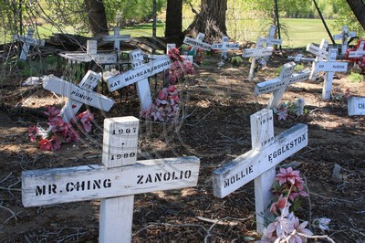
The drive then gave me majestic views of the Dillon Pinnacles of Gunnison. The pinnacles were formed from a huge volcanic mud flow. My journey west on US 50 would end at Montrose, where I moved south on US 550 and onto the San Juan Skyway, getting me closer to my Mesa Verde adventure.
The 230 mile San Juan Skyway runs along the astonishing and amazingly sculpted landscape of the San Juan Mountains, with its many jagged volcanic summits with heights of over 10,000 feet. The half way mark on the Skyway would lead me to Mesa Verde. The Skyway is aptly named with a stretch of steep, narrow winding roads with breathtaking views of the snow capped Red Mountain. People would describe this stretch as “treacherous” and I agree. It is a two lane road that is really one and one half lanes wide with no guardrails as it runs along steep cliffs of the 11,018 ft mountain and slopes with 200 feet drops. Although it was a white knuckle, heart pounding, prayer filled drive the scenery was unbelievable, but unfortunately the road gave me no opportunity to pull over to photograph any of it. Once again the sight of crosses along the road caught my eye. I understood the meaning of these immediately and continued to concentrate on the road ahead of me. The winding road brought me past Bear Mountain and the Red Mountains, and the old mining towns of Silverton and Quray and down to Durango. When reaching Durango, I needed to head west on US 160. I came to a realization that I would not get to Mesa Verde by nightfall. I spent the night in Durango with plans to drive the additional fifty miles through La Planta County to the park the next day.
Stranded (Part 3 of 8)
 The Colorado Springs Loop extends 220 miles across US 24 west to the top of Pikes Peak, then over the Rocky Mountains and south on US 285 into Pike National Forest, then along US 50 and the Arkansas River and back to Colorado Springs. My first stop on the loop was the 1300+ acre Garden of the Gods Park, a Colorado Springs City park. The park consists of massive and impressive red sandstone formations carved over the millenniums by nature’s forces. They are not unlike those found within Arizona’s Navajo Monument Valley. The noticeable differences are that the park is free to enter and you can get up close and touch the monoliths, some of which can be climbed. While walking through the park admiring the massive formations, I witnessed three people getting ready to scale the face of one. The huge formations have appropriate names. Names such as, Cathedral Valley, Siamese Twins, Kissing Camels and Balanced Rock.
After leaving the park, I traveled along US 24 west and my next stop was the cliff dwellings in Manitou Springs. These dwellings were built in the 1100’s by the Ancestral Puebloan, formally known as the Anasazi, but moved to the present site during the 1800’s. They show how the population lived within the side of the mountain. This site allows you to experience how they lived in the past by allowing you to walk through the rooms without hindrance. It’s odd to think these people were called primitive when they were able to build these homes without all the modern machinery that we have today. After spending a couple of amazing hours photographing and walking through time at the cliff dwellings as well as The Garden of the Gods Park, I moved onto my next adventure.
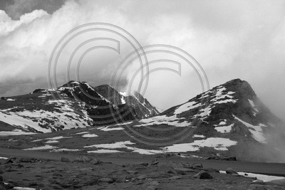
The previous night, I was debating if I would go to Pikes Peak, a mountain that has a 14,110 foot summit. I was reading over a brochure for Pikes Peak’s Cog Railway, a railway that moves people to the summit. I could see from the base of the mountain that the top was snow covered and had clouds hugging the summit. In the city below, the warm weather prompted my wearing shorts and a tee shirt. I knew I was not dressed to experience the ride up the Railway and I wasn’t really sure that I wanted to drive up the mountain. That morning, I left the motel with no intention of going up that mountain, but after leaving the Cliff Dwellings, I saw a sign for the entrance to Pikes Peak Highway. Pikes Peak was the inspiration behind America the Beautiful. It is the “purple mountain majesties above fruited plains.” As I drove past it, I convinced myself that a trip to Colorado would not be complete without going up the mountain, so I decided to drive up the length of the highway.
As I was paying my entrance fee to the park ranger, he told me that the weather at the top had drastically diminished visibility and I wouldn’t see anything off the mountain. Since the point of driving to the summit is to say that you drove to the top, I was fine with not being able to see the city down below. The 38 mile round trip started with a warning. At least a half a tank of gas would be needed to make it back down the mountain. I looked at the gas gauge and I had three quarters of a tank left. Plenty to make it back. I started the steep, winding and hairpin curved ascent. At first the road was paved, but shortly became a gravel road without guardrails. With every turn and mile, the temperature got colder and the wind picked up as tiny snow flurries began to fall. As I continued my drive up, I saw the mile markers increase incremental. At the half way, mile nine marker, I started the count down. Ten more miles to go.
While looking out the window, I saw the vegetation starting to get more scarce and the towering evergreens not being as tall as they were a few miles lower. As I continued up the mountain, I began to see nothing but dirt, boulders, rocks and snow on the side of the road. The environment was so harsh that nothing grew. Then I started to notice the dense low clouds moving in and not being able to see the oncoming cars or the taillights of the car in front of me. I slowed to a crawl as a looked outside my right window and saw the edge of the cliff as I rounded up the mountain. I could hear the wind pick up and slightly rock my Jeep as I inched around the winding miles. By that point, I closed the windows and turned on the heat as I continued to count the remaining miles up the mountain.
At mile 18, a mile below the summit, the fog cleared a little and I could see blue sky. A perfect picture. I pulled my Jeep as close to the edge of the road that I could. My camera was on the front passenger seat. I opened my door, flipped the switched to unlock the doors, then exited, closing the door behind me. I walked around the front of my car and pressed the passenger door handle so I can get the camera. The door was locked. I knew at that second that instead of unlocking the other three doors, I somehow locked all of the doors. With the key in the ignition and the engine still running, I quickly ran to the driver’s door and my worst fear materialized. I was trapped outside my car in near freezing temperature at about 13,000 feet wearing shorts and a tee shirt. Although I knew I was screwed, I tried each door again. I even checked the tailgate. They were all locked. At that moment while the wind continued to gust, the fog moved in again. I would learn later that the outside temperature was 35 F degrees. Thoughts of stories of unprepared hikers dying of hypothermia filled my head. I continued to struggle with the doors and to think of my options. I had declined the insurance coverage on the rental so breaking the window was not an option, at least not at that moment. To escape the gusting winds, I moved away from my car and closer to the mountain wall. I thought to myself that the doors couldn’t be locked so I tried them again. They were still locked.
Shortly, two hikers, a man in his forties and a boy around ten dressed in winter hiking gear, were coming down the mountain, and I told them that I was locked out. Again, I was thinking about ill-prepared hikers not telling people about their location. I then pointed out my attire to them and they agreed that I wasn’t dressed for the weather and they continued to walk past me. About five minutes had elapsed and the combination of the cold, wind, fog and the lack of oxygen at 13,000 feet resulted in my mouth drying out. Shortly thereafter, a car carrying a group of people started to come down the mountain. I moved away from my car and waved them to stop. The driver was hesitant, but I approached his car to make him stop. At first the driver did not open his window. I told him that I was locked out of my car. He seemed to not understand me. Because of the dry mouth, I then found myself having difficultly speaking. I repeated that I was locked out of my car and asked if he could take me down to the ranger station. In broken English, he told me that he needed to make additional sightseeing stops while going down the mountain.
In the meantime, an SUV made its way down the from the summit and was about to drive around us. The car I had stopped started to move on. I waved at the SUV. I saw a woman in the passenger seat and she smiled and started waving back to me as the driver continued to drive. I then changed my wave indicating that they stop. The car stopped and the woman opened her window. Because of the combination of the dry mouth, wind chill, cold and altitude, not to mention the thought of hypothermia, I found difficulty concentrating on forming a sentence. In my own broken English, I explained my predicament and that I needed them to drive me down the mountain to the ranger station. Their SUV was also packed with people, but the woman gladly said that they would drive me down. She got out and told me to sit in the front with her husband and that she would squeeze in the back with her family. They introduced themselves. Her name was Ann and her husband was named Chris. They were from Minnesota, but he is in the Army and stationed in Colorado. The people in the back were family and were visiting, so they decided to go to the mountain.
While they drove me down the mountain to the ranger station, my thoughts were no longer about dying of hypothermia, but of my car running out of gas. The 18 mile drive down lasted about 40 minutes. When I got to the ranger station, I told them what happened. They offered to unlock the door but advised against it since it has side air bags. They suggested a tow or a locksmith. I called a locksmith who said it would take him 45 minutes to get to the base of the mountain. As I hung up the phone, I started to do the math. The car would be idling for at least 2 hours. It was 40 minutes down the mountain. 45 minutes for the locksmith to get there. 40 minutes to get back up and then the time needed to get the door opened and get back down the mountain and into town. I started to have second thoughts. I probably would have needed a tow more than a locksmith, but it was too late to cancel.
I waited for the locksmith. As he promised, he arrived 45 minutes later in a van. He asked me if I needed a ride back up. I said that I would, thinking to myself that I hope he was better at opening up locks than asking dumb questions. Little did I know, the fifty year old locksmith had his thirty-something “lady friend” in the passenger seat. The van’s back had no seats and was packed with tools on shelves. He told me that there was space in the back for me to sit on the floor. As we started our climb up, speeding, the thought of what could happen to me entered my mind as I sat on the floor without a seat belt, below all of his heavy tools, as the van rounded all of the curves in the fog and wind. Dying from Hypothermia may have been better. We got to my Jeep in about a half hour. To my surprise, the Jeep was still running and it still had a half a tank of gas, enough to get me back down the mountain and into town for a new fill up. After a few attempts in strong wind gusts and the fog using different tools, the locksmith was able to open the door for a fee of $85. I then got in, determined to finish my trip up to the mountain top. To brave the elements, I put on a pair of sweats that I had in my luggage. I also securely attached the spare key to my belt, where it stayed for the rest of the trip. I drove up the remaining mile to the summit to experience being on top of the world. Although I wasn’t excited while the events were being played out, it turned out to be a thrilling ride and experience. I can say I survived Pikes Peak.
My plan to drive the 220 mile loop back to Colorado Springs ended on Pikes Peak. I returned to Colorado Springs using the same road I traveled that morning. The loop would have to wait for the following day.
Rocky Mountain Ramble (Part 2 of 8)
On my way to the Rocky Mountains on I-25 and south of Estes Park in a town called Mead, I found an abandoned weigh station on the service road running parallel to the interstate. It was on Frontage Road and was made out of wood frame and aged to the point of peeling paint and rust. I typically avoid interstates so I do not miss these types of opportunities and luckily I was able to see it from the expressway. This was going to be my first photo of the trip so I needed to get off the interstate, make a u-turn and drive south so I could get up close and take the photograph. After studying the site and taking several photos, I then continued on the road and entered Estes Park. The park consists of thousands of acres of Wilderness in the center of nearly 50 mountain peaks and their breathtaking views. My journey past Estes ended with the start of the “Rocky Mountain Ramble.”
The Ramble involved driving 110 miles starting with US 34 across and over the mountain, from the east side to the west side. It then extends south onto US 40 through the Apapho and Roosevelt Forests. However, my plans didn’t turn out the way I wanted. When I entered the park, I was told by the ranger that US 34 was closed nine miles up the mountain because it was still covered in snow. Changing my plans, I drove the nine mile loop within the Rocky Mountains and discovered that they have many dirt roads, so I decided to take one to see where it might lead.
When deciding what type of vehicle to rent, I decided on a SUV and knowing that the Jeep Liberty has four wheel drive, I opted for it. When I moved onto the dirt road, I looked to shift into four wheel drive. I glanced all along the center console. The controls were not there. I then looked under the dash. Still no controls. I pulled to the side of the road to consult the manual, which indicated the controls were on the center console. They were not. I would learn later that the rental agency does not rent four wheel drive vehicles to discourage renters from driving off road. Had a known, I would have gone with a convertible sports car, my usual rental choice. Although the Jeep did not have four wheel drive, I continued onto the dusty road with all of its dirt and gavel. The road gave me great views of the snowcapped Rocky Mountain peaks. As I continued up the road, signs indicated that only vehicles with Colorado state plates where allowed further. The registration sticker on the window showed the contrary. The plates were from Texas. I continued up the road. I passed a second sign - only Colorado plates allowed. Since I already had two strikes against me, two wheel drive and Texas plates, I pulled over and photographed the graceful mountain peaks and moved back to the paved road. I concluded the nine mile loop within the park and exited, moving onto the “Peak to Peak Scenic Byway”.
This 60 mile byway extended south from Estes Park along the east side of the Rocky Mountains and Roosevelt Forest. The Byway is a combination of county roads which happily does not include any tolls. The road gave impressive views of Rocky Mountains’ Longs Peak, rising over 14,000 feet. Longs Peak is the peak depicted on the back of the Colorado State Quarter. The Byway ends in the city of Black Hawk. The city’s buildings’ 1800s historic architecture of the mining industry have been preserved. However, it appears that every building in the city has been converted into a casino and oddly it seems to be the only listing in the AAA Tour Book guide with no mention of its rich past or points of interest other than to list the 10 casinos as bullet points and the town’s population of 118.
My next destination was Colorado Springs, and with no clear road to take, I grudgedly hopped on I-25 to drive 100 miles south, so that I could spend the night in that city with morning plans to drive the “Colorado Springs Loop.”
Day One - “Trapped” on a Highway (Part 1 of 8)
During the last week of May 2008, I drove around Colorado to take in and photograph the beauty of the state with mountains that inspired the unofficial American anthem. It was a feast for the senses as I saw hundreds of mountain peaks, canyons, ravines and gorges. I heard the roar of rivers churning  with angry waters and the sounds of birds, as well as the sound of silence. I felt extreme heat and freezing winds. Yet at other times, I smelled the scent of millions of pine trees. I covered the state using steep, winding and sometimes heart-pounding roads. I became stranded. I was astounded, amazed and educated. I was reminded of times long gone and that natural american resources are to be protected for generations yet to come.
Flying into Denver from NYC, I rented a Jeep and started my quest to drive and see as much of Colorado that I could. By the end of the week, I included a detour to Utah and had driven 1744 miles while snapping 1190 photographs. It was an amazing week, starting with Pikes Peak, then Mesa Verde and into the deserts of Utah. Crisscrossing nearly two-thirds of Colorado via the American Byways, I avoided interstate highways when possible.
Over the first three days, I drove nearly 500 miles, from Denver to the Rocky Mountains to Colorado Springs and to Pike’s Peak. Since the adventure of driving is not knowing where I’m going and letting the road lead, I didn’t map out my route from the Denver Airport and ended up losing most of Saturday driving in a circle. My intention was to drive north and loop around and go into Rocky Mountain National Park.
I ended up getting “trapped” on a state highway toll road that started out in a northernly direction but ending up going south and then west. To make matters worse, the toll road charged $2.00 every few miles along the length and 75 cents for each exit. None of the exits had attended toll booths and only accepted exact change and Colorado’s version of EZ Pass. I only had a debit card and a few bills.
The $2.00 booths were attended and accepted my bills, but since I did not know that the following exits needed exact change, I did not ask for the bills to be broken. I ended up driving miles out of my way before finding an attended toll exit.
I eventually got off and picked up a coffee and a map and charted my course to the park and proceeded to take I-25 North. To my amazement, the entrance took me back on to the tolled state road. Approaching the entrance, I saw the familiar exact change sign. I wondered if the change from my coffee would be enough to get me through, but since it was a Starbucks I came up short. Luckily, I found the remaining coins scattered in the car. I entered the “freeway” and drove to the I-25 exit and paid $2.00 one last time at the exit. I then drove north to Estes Park and decided to stay the night and start my adventure through the Rocky Mountains in the morning.